
Transition Chesterfield
Response to the draft HS2 Station masterplan consultation
https://www.chesterfield.gov.uk/HS2-station-master-plan#
February 2021
Summary
The station masterplan offers a once in a generation opportunity to vastly improve the area around the station, improve connectivity for pedestrians, cyclists and other vulnerable road users, and contribute to climate objectives. The area around the station certainly needs positive physical change but the plan presented represents a huge missed opportunity in that regard and risks becoming a white elephant within a few years time.
There are many good objectives and stated intentions in the masterplan. Unfortunately there is a fundamental conflict in the plan which is caused by a design centred around a new road (yet to receive planning permission) and vehicle access, driven by a misguided idea that roads promote economic development. The station masterplan needs to have a contingency plan if the new link road does not go ahead. If it does go ahead then there needs to be some commitment to close St Mary’s Gate to traffic to ensure that road capacity overall is not increased.
The current masterplan which is based around a new road through the station, appears to conflict with some of the objectives, has inappropriate or missing objectives, has omitted or overlooked many key design principles, has ignored several strategic walking and cycling routes, has ignored modern design guidance, and is designed to make it easier for people to drive to the station, rather than making it easier to access the station without a car. By contrast many more progressive towns and cities are now removing vehicle access from their stations to make it easier for people to walk and cycle, and to reduce carbon emissions.
Transition Chesterfield recommends adding new objectives ‘improve accessibility for all, especially vulnerable road users’; ‘reduce carbon emissions’; ‘make the station safer and more pleasant for visitors and residents’; ‘increase the number of visitors to Chesterfield arriving by train’, ‘encourage more sustainable travel’.
We also recommend the following amendments to the masterplan design (in the event that the Hollis Lane Link road goes ahead):
- Install a Copenhagen style crossing across the Hollis Lane Link rather than a Toucan crossing, to give pedestrians (and cyclists) priority.
- Alternatively, instead of a Toucan, this whole area could be shared space with traffic restricted to 5mph between the mini roundabout and the multistorey entrance.
- Have the cycle route on the Chesterfield Hotel side of the road leading up to connect with the existing cycle route on Brewery Lane, but have the pedestrian route on the other side (so pedestrians take the shortest route)
- Install a Copenhagen style zebra crossing across Crow Lane (or make it shared space for pedestrians/cyclists/vehicles) and introduce a dedicated walking route between Crow Lane and Brimington Rd.
- Install another Copenhagen style zebra crossing on Brimington Rd where the route above emerges, to allow pedestrians to cross safely onto the West side of Brimington Road.
- From the West side of Brimington Rd provide safe segregated walking/cycling links into Waterside and onwards to Chesterfield College.
- Route the station cycle link behind the bus/taxi rank (instead of across it) and have it emerge at the crossing with the Hollis Lane link (in line with Chesterfield Cycle Campaign recommendations).
Introduction
Transition Chesterfield is a local community group aiming to make Chesterfield more resilient and sustainable. We want to create positive local solutions to the twin challenges of ‘peak oil’ and climate change and make our town a better place to live. Note that we have commented on previous local plans, masterplans and gateway proposals over the last few years, and consistently supported better access to the station in terms of walking, cycling and public transport (see Annex).
The station masterplan offers a once in a generation opportunity to vastly improve the area around the station, improve connectivity for pedestrians, cyclists and other vulnerable road users, and contribute to climate objectives. The area around the station certainly needs positive physical change but the plan presented represents a huge missed opportunity in that regard and risks becoming a white elephant within a few years time.
We support many elements of the plan including removing traffic access from the front of the station, having a pedestrian boulevard, opening the lines of sight to the crooked spire and making the town centre route more legible, and providing a separate walking and cycling bridge across the A61. There are also many good objectives and stated intentions in the masterplan. Unfortunately there is a fundamental conflict in the plan which is caused by a design centred around a new road (yet to receive planning permission) and vehicle access, driven by a misguided idea that roads promote economic development. The current masterplan which is based around a new road through the station appears to have omitted or overlooked many key design principles and is designed to make it easier for people to drive to the station, rather than making it easier to access the station without a car.
We are also concerned about the future-proofing of the plan in terms of demand for the retail/business space in the new buildings, and contingencies if this cannot be rented/sold, particularly if HS2 Phase B does not go ahead.
Design conflicts with many of the masterplan objectives
This sub-optimal design will increase the number of cars and the current design will actually increase conflict between vehicles and vulnerable road users and undermines many of the other objectives and stated intentions of the plan including the following:
- ‘to reinvent the train station and rail travel as an integral part of the town centre’ (vision p4)
- ‘an accessible central location that could reduce the need to travel by car’
- ‘local plan seeks to prioritise pedestrians, cyclists and public transport in terms of how the area works’
- ‘the masterplan should recognise the station area importance within the walking and cycling as much as reasonable when balanced against potentially competing operational considerations’ (strategic policies, p10)
- ‘a masterplan should show some flexibility to avoid becoming obsolete within the next 5 years’
- ‘it is likely that the need to recover and grow the economy and reduce carbon emissions will become strong themes over the next 5 years’
- ‘provide a stepchange in connectivity to the station’
Inappropriate or missing objectives
We disagree with several of the objectives which feel inappropriate for a 21st century design, including:
- “Creating a new link road” :We do not agree that a road should be an objective in its own right. There is already an objective to increase connectivity so what other purpose does a a new link road provide? This is particularly objectionable when the new road has not even been granted planning permission and is likely to have negative impacts on the town in other ways, and when there is a strategic policy (stated above) to reduce the need to travel by car. What happens if the traffic modelling shows, as is likely, that a new link road will create unacceptable levels of congestion on the A632, doughnut or other parts of the road network and increased carbon and air pollution emissions? The station masterplan needs to have a contingency plan if the new link road does not go ahead. If it does go ahead then there needs to be some commitment to close St Mary’s Gate to traffic to ensure that road capacity overall is not increased, and is the main reason why a link road was proposed many years ago.
- “Encourage global tourism”:It is not clear why this is an objective in a masterplan for Chesterfield in the year 2021? How on earth can this be compatible with an objective to reduce carbon emissions? If the objective is to increase the number of visitors to Chesterfield arriving by train, which is more understandable, this should be stated clearly.
- “Maintain carparking” :We understand that this is part of the EM Trains franchise but this seems a totally inappropriate objective for the masterplan that conflicts with the aims to reduce car travel and carbon emissions. While a multi-storey carpark is a more efficient use of land than the existing surface carparks, the objective for the long term should be to reduce access to the station and therefore reduce the need for carparking.
We suggest that there are many objectives that would be far more appropriate with modern planning principles that should be included:
- Improving accessibility for all, especially vulnerable road users
- Reducing carbon emissions
- Making the station safer and more pleasant for visitors and residents
- Encourage more sustainable travel
- Increase the number of visitors arriving in Chesterfield by train
Design principles and drivers not implemented
We support many of the design principles (p39) (eg to improve north-south pedestrian and cycle links through the masterplan area (connecting to Waterside and the Trans Pennine Trail), or sustainable development that achieves carbon reduction strategies, and climate change targets). However we disagree with some of the principles such as the Station Link Road (details and impacts still unknown) and a multistorey carpark that will accommodate growth) which undermine other objectives, and feel that key principles have been missed (eg improving pedestrian connectivity to Waterside and Chesterfield College).
We also support the design drivers (p38) (eg Improving Pedestrian Permeability + Improving Cycle Infrastructure) but as with the principles there is no evidence that some of these have been implemented. For example north-south connectivity for pedestrians and cyclists is arguably worse than it is at present, and pedestrian and cycle accessibility has not been prioritised.
Although we support many elements of the plan including removing traffic access from the front of the station, having a pedestrian boulevard, opening the lines of sight to the crooked spire and making the town centre route more legible, and providing a separate walking and cycling bridge across the A61 (note that this is referred to in the masterplan as a ‘footbridge’ but is actually a cycle bridge as well), overall the masterplan is fundamentally designed around motorised vehicles, contrary to good transport planning and design principles.
Although the design is supposed to support the development of a strong sense of local character, other than the viewpoint of the Crooked Spire we do not see any evidence of a particular Chesterfield character in the design.
Strategic walking and cycling routes ignored
We are appalled that a key strategic walking and cycling route, the station cycle link built by Derbyshire County Council just 4 years ago, with a £1million grant from the government administered by Sustrans, will be severed and undermined by this masterplan. ~The only mention in the masterplan appears very dismissive (p30):
“From the south the study area is only accessible by the dedicated shared footpath and cycleway as vehicular access is constrained by the existing retail land ownerships. The shared route is enclosed by fencing and is unlit and screened by vegetation in parts and therefore not always overlooked.”
This is actually a heavily used route which is popular with pedestrians and cyclists and provides a key ‘missing link’ in an almost entirely segregated walk/cycle route from the station almost to the Peak District. As part of Phase 1 of the Hollis Lane Link, an additional pedestrian link will be provided to the station route at Hollis Lane which will make it much more accessible for people walking from Spital and Hady.
A key principle of the masterplan shown in the ‘principles diagram’ (p40) is to ‘take existing and proposed cycle routes into consideration’. Yet the significance of the Station Cycle link and onward connections with other routes appears to have been entirely overlooked or at best an afterthought in the masterplan. For example the ‘strategic connections’ diagram shows only roads, no cycle routes and only a single pedestrian route to the town centre. No pedestrian or cycle links to Chesterfield College or Waterside or links to the cycle station link are considered. The aerial photo of the study area on p15 shows 7 carparks but not the station cycle link or Chesterfield College a major destination from the station. Perhaps it is not surprising that the illustration ‘masterplan approach’ (pp51) doesn’t even show any cyclists!
Modern design standards and guidance ignored
The infrastructure provided fails to meet government design standards for cycling (LTN 1/20)[1] or the principles of London’s Healthy Streets guidance[2] which was recommended to the consultants. For example:
- Networks and routes should be Coherent; Direct; Safe; Comfortable and Attractive (LTN 1/20)
- Cycle routes should be at least as direct – and preferably more direct – than those available for private motor vehicles
- Walking, cycling and using public transport should be the most attractive ways to travel, and making them more enjoyable will benefit everyone, including those already travelling on foot, by bike or public transport. (Healthy Streets Guidance)
Other cities are reducing not increasing car access to their stations
Chesterfield seems to be out of step with many other places which are reducing not increasing car access to their stations.
For example Sheffield is planning to relocate the inner relief road to the back of the station “By removing the road barrier, and opening up new green space, the station will be better and more safely connected with the bus station and the city core.”
Stoke-on-Trent is also banning cars driving past the rail station, making the road outside the front of the station pedestrianised and building new cycle routes to the back of the station https://www.stokesentinel.co.uk/news/stoke-on-trent-news/revealed-multi-million-pound-vision-3662191
Many other cities, including Nottingham, Leicester and Derby are planning public realm improvements to make it easier for people to walk and cycle to the station. However Chesterfield’s plan, in many ways, will actually make it more dangerous.
Recommendations to improve routes for pedestrians and cyclists
Although the masterplan states that it wishes to provide a ‘more connected cycle network’ and ‘more legible pedestrian links’ this may be the case for pedestrians/cyclists going from the station to town but is not the case for other strategic routes such as from the station to Chesterfield College or Waterside or for pedestrians/cyclists going north-south from the station cycle link to Brimington Rd and the canal.
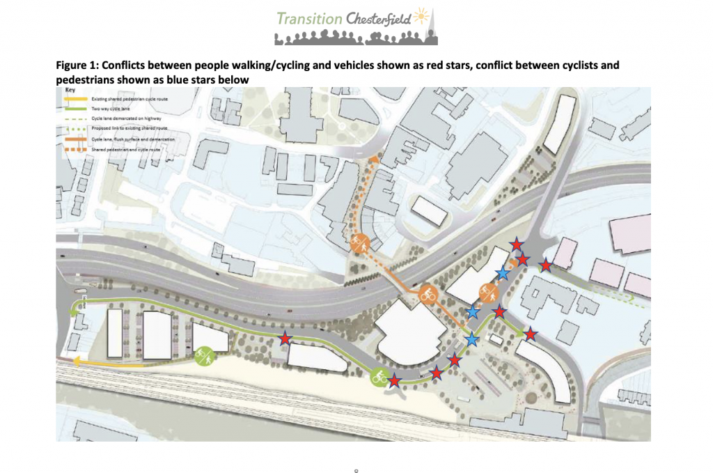
Below we have considered the route for pedestrians and cyclists and the conflicts, hazards and inconvenience they encounter as a result of the masterplan (see Figure 1 on pp7):
For pedestrians walking to/from the station to Chesterfield College
- Pedestrians come out of the station and are forced to wait for a light controlled crossing which gives priority to cars to cross the new Hollis Lane Link Rd.
- They then have a shared path with cyclists (not clear if this is a one or two way cycle lane), contrary to new government guidance.
- They will then have to walk across a new servicing vehicular access to the site of the old Chesterfield Hotel.
- They then have to wait for another light controlled crossing which gives priority to cars, to cross back to the north side of Brewery St.
For people on bikes cycling from Brimington trying to connect to the Station Link onwards to Derby Rd or the Hipper Valley Trail
- People cycling south on the carriageway of Brimington Rd will need to turn left on mini-roundabout, which will have been made faster and more dangerous by the proposed new design
- They will then have to cycle past the junction with Crow Lane onto a short section of cycle lane
- They will then reach the toucan crossing where there will be immediate conflict with pedestrians wanting to cross the road
- They will then cycle onto the shared path adjacent to the Hollis Lane link and have to cross the entrance/exit to the taxi area where there is immediate conflict with vehicles accessing the drop off/taxi rank
- They then have to cross the exit with the bus rank where there is conflict with buses entering/exiting the area
- They then have to cross another two road junctions before reaching the station cycle link
For cyclists coming from the station cycle link wanting to go north to Brimington Road and the Trans Pennine Trail via the canal they have the opposite problem. However when they cross the Hollis Lane Link via the Toucan Crossing and turn right they are on a shared walking/cycling path on the south side of Hollis Lane Link. They then have to somehow get onto the road again to negotiate a dangerous mini-roundabout to be able to access Brimington Rd. When they get onto Brimington Lane they have the added problem, created by poor cycle infrastructure design for Waterside, that they have multiple road entrances to cross.
This is clearly not ideal for pedestrians and cyclists. We recommend the following amendments to the design (in the event that the Hollis Lane Link road goes ahead):
- Install a Copenhagen style crossing across the Hollis Lane Link rather than a Toucan crossing, to give pedestrians (and cyclists) priority.
- Alternatively instead of a Toucan, this whole area could be shared space with traffic restricted to 5mph between the mini roundabout and the multistorey entrance.
- Have the cycle route on the Chesterfield Hotel side of the road leading up to connect with the existing cycle route on Brewery Lane, but have the pedestrian route on the other side (so pedestrians take the shortest route)
- Install a Copenhagen style zebra crossing across Crow Lane (or make it shared space for pedestrians/cyclists/vehicles) and introduce a dedicated walking route between Crow Lane and Brimington Rd.
- Install another Copenhagen style zebra crossing on Brimington Rd where the route above emerges, to allow pedestrians to cross safely onto the West side of Brimington Road.
- From the West side of Brimington Rd provide safe segregated walking/cycling links into Waterside and onwards to Chesterfield College.
- Support the Chesterfield Cycle Campaign’s plan to route the station cycle link behind the bus/taxi rank (instead of across it) and emerge at the crossing with the Hollis Lane link.
There should be dedicated cycle parking outside or inside the station – to allow door to door access.
Annex: History of Transition Chesterfield comments
on connectivity to Chesterfield Railway Station
- Pedestrian Audit 2010 – recommended decking over the A61; zebra crossings across Crow Lane, Brimington Road and opposite Chesterfield hotel, and moving the mini roundabout further south.
- Response to sites and boundaries consultation 2013 – comments about need to improved public transport and pedestrian links to station and land safeguarded next to the station for a public transport interchange
- Response to Gateway enhancements 2013 – recommended better pedestrian crossings across Crow Lane outside the train station, across Corporation St by the Chesterfield Hotel and across Brimington Road leading up to the College. The footbridge across the A61 also needs major improvements (eg. decking or enclosing or higher walls to shield pedestrians from traffic) and any work should be coordinated with the new Hipper Trail cycle route extension to the station. Also supported the development of a public transport interchange adjacent to the station. (all comments subsequently ignored by CBC in sub-standard work done outside station, which we were not consulted on)
- Town Centre cycling/walking audit 2015 – one of a series of audits led by members of a DCC working group (which included CBC) as part of a strategic review of cycling in Chesterfield. Recommendations included better signage and surfacing, as well as additional links from the new cycle station route. We were told that many of the connectivity issues around the station would be resolved through the development of Waterside.
- Transition Chesterfield comments on new Local Plan (2017) – reiterated need for public transport interchange at station
- Numerous objections to various Waterside development applications regarding poor walking and cycling connectivity. Eg CHE/15/00119/FUL; CHE/18/00626/REM1; CHE/19/0016/REM; CHE/19/0007/REM; CHE/19/00069/DOC.
Figure 1: Conflicts between people walking/cycling and vehicles shown as red stars, conflict between cyclists and pedestrians shown as blue stars below
[1] https://assets.publishing.service.gov.uk/government/uploads/system/uploads/attachment_data/file/951074/cycle-infrastructure-design-ltn-1-20.pdf
[2] https://tfl.gov.uk/corporate/about-tfl/how-we-work/planning-for-the-future/healthy-streets