


Walking and Cycling: What is Transition Chesterfield doing?
1. Improvements to walking and cycling routes
Transition Chesterfield want to see Chesterfield become more pedestrian and cycle-friendly.
See our new Town Centre pedestrian crossing survey This shows that people are being put at risk or inconvenienced by broken lights, overly long waiting times, or overly short crossing times.
See our new Walk of Fame and Walk of Shame series below, highlighting facilities for pedestrians in Chesterfield that deserve praise (walk of fame) or need improvement (walk of shame).
Walk of fame no. 1: Zebra crossing near Pomegranate, St Mary’s Gate
Walk of shame no. 1: Pedestrian ‘refuge’ on Holywell St
Walk of fame no. 2: Elder Way
Walk of shame no. 2: Stephenson’s Place and Cavendish St
Walk of fame no. 3: Bridge leading to Ravenside
Walk of shame no. 3: Pavements around Ravenside
Walk of fame no. 4: Alzheimers Garden
Walk of shame no. 4: Crossing Foljambe Rd, West Bars
Walk of fame no. 5: New Beetwell St Pedestrian Bridge
Walk of shame no. 5: Access to ‘The Range’ retail park
In order to promote walking and reduce dependency on cars Transition Chesterfield worked with Chesterfield Borough Council, Derbyshire County Council, the Ramblers, and Walking for Health groups in 2013, to map and audit key walking routes in the borough, and identify gaps and areas for improvement. We produced a detailed list of hundreds of improvements needed across Chesterfield. For info on results of the audts and suggested improvements for different areas please contact hello@transitionchesterfield.org.uk.uk . For an earlier audit of improvements in and around the town centre click here Pedestrian Audit July 2010
Transition Chesterfield works closely with the Cycle Chesterfield who aim to improve cycling infrastructure and facilities in Chesterfield. Cycle Chesterfield have lots of useful info and resources on their website and produce the Chesterfield Cycle Map.
Cycle Chesterfield work closely with Derbyshire County Council to implement the ‘Chesterfield Cycle Network’. A long term goal to achieve a joined up network of colour coded cycle routes across the town. Here is a page with the schematic map of the system when complete. Here is a Myth busting document about the proposed Chesterfield East West Walking and Cycling Route.
Transition Chesterfield was one of a number of Derbyshire groups who submitted a Proposal for an emergency transport plan for Derby and Derbyshire to Derbyshire County Council in May 2020.
2. Planning issues
We need a safe, sustainable and integrated transport system but the way we travel and the continued growth in road traffic is damaging our towns, harming our countryside and contributing to climate change. Land use planning needs to be closely integrated with transport planning to achieve a sustainable transport system. By shaping the pattern of development and influencing the location, scale, density, design and mix of land uses, planning can help to reduce the need to travel, reduce the length of journeys and make it safer and easier for people to access jobs, shopping, leisure facilities and services by public transport, walking, and cycling.
Transition Chesterfield makes submissions on planning and transport planning consultations or individual planning applications to try and ensure that transport and land-use planning are better integrated to reduce our dependency on cars. Please see attached our response to the consultation on the Chesterfield Staveley Regeneration Route here.
3. 20’s Plenty
20’s Plenty is a national campaign to reduce speed limits in urban residential areas to 20mph. Over 50 local authorities have done or are starting to do this.
We support this campaign for Chesterfield because the benefits are enormous in terms of reduced road casualties, improved public health and a better quality of life for local people in residential streets where people walk and cycle.
The UK’s Public Health Manifesto recommends 20mph limits to encourage more walking and cycling. In Europe 20mph speed limits are the foundation of cycling and walking policies. 20mph is the top evidence based policy to increase active travel according to a Public Health England and LGA report.
In 2015 Derbyshire County Council (DCC) consulted on introducing 20mph limits on residential streets. Follow this link for our Response to the consultation. We argue there is sufficient evidence on the benefits to warrant the introduction of area-wide 20mph limits in Chesterfield. There are now over 50 local authorities implementing 20mph as the default speed limits in residential areas. We urge DCC not to wait until it is a national requirement.
Click here for a leaflet on how 20mph speed limits can benefit Chesterfield.
4. Walk leaflets
Transition Chesterfield produced a series of 6 leaflets of car-free walks in the Peak District for people who don’t have cars or who want to leave them at home. These were funded by the Peak District National Park Authority’s Sustainable Development Fund, and supported by Peak Connections. Links below to download the leaflets. Because the bus times have radically changed since these were first published, we have omitted the original bus timetables and just provided routes, so you will need to check bus times at www.derbysbus.info/times/
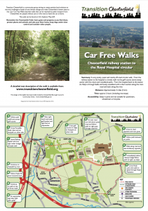 Our ‘Car Free Walk’, is a circular walk from the railway station to the hospital and back. Download the leaflet here.
If you would like to get involved or for more information on any of the above please contact hello@transitionchesterfield.org.uk.uk
Other ‘Car Free Walk’ leaflets;